Summary
The European plate has a 4.5 Gy long and complex tectonic history. This is reflected in the present day large scale structures. The new digital Moho depth map is compiled from more than 250 data sets of individual seismic profiles, 3D models obtained by body and surface waves, receiver function results, and maps of seismic and/or gravity data compilations. We have compiled the first digital, high resolution map of the Moho depth for the whole European plate extending from the Ural Mountains in the east to mid-Atlantic ridge in the west, and from the Mediterranean Sea in the south to the Barents Sea and Spitsbergen in Arctic in the north. In general three large domains within European plate crust are visible. The oldest Archean and Proterozoic crust has thickness 40-60 km, continental Variscan and Alpine crust has thickness 20-40 km, and the youngest oceanic Atlantic crust has thickness 10-20 km. An estimation of uncertainty has been computed for the area of the Moho map.
Marek Grad (1), Timo Tiira (2) & ESC Working Group#
(1) Institute of Geophysics, University of Warsaw, Pasteura 7, 02-093 Warsaw,Poland
(2) Institute of Seismology, University of Helsinki, Helsinki, P.O. Box 68, FIN-00014, Finland
_____________________________________________________________________________________________________
# ESC Working Group comprises: M. Behm, A.A. Belinsky, D.C. Booth, E. Brückl, R. Cassinis, R.A. Chadwick, W. Czuba, A.V. Egorkin, R.W. England, Yu.M. Erinchek, G.R. Fougler, E. Gaczynski, A. Gosar, M. Grad, A. Guterch, E. Hegedus, P. Hrubcová, T. Janik, W. Jokat, E.E. Karagianni, G.R. Keller, A. Kelly, K. Komminaho, T. Korja, J. Kortström, S.L. Kostyuchenko, E. Kozlovskaya, G. Laske, L. Lenkey, U. Luosto, P.K.H. Maguire, M. Majdamski, M. Malinowski, F. Marone, J. Mechie, E.D. Milshtein, G. Motuza, S. Nikolova, S. Olsson, M. Pasyanos, O.V. Petrov, V.E. Rakitov, R. Raykova, O. Ritzmann, R. Roberts, M. Sachpazi, I.A. Sanina, M.C. Schmidt-Aursch, I. Serrano, A. Špicák, P. Sroda, F. Šumanovac, B. Taylor, T. Tiira, A.G. Vedrentsev, J. Vozár, Z. Weber, M. Wilde-Piórko, T.P. Yegorova, J. Yliniemi, B. Zelt, E.E. Zolotov.
If you find the moho map useful, please cite:
Grad, M., Tiira, T., and ESC Working Group, 2009. The Moho depth map of the European Plate, Geophys. J. Int. 176, 279-292. doi: 10.1111/j.1365-246X.2008.03919.x.
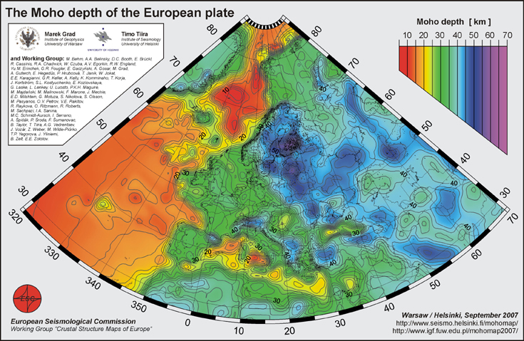
Figure 1. The Moho depth of the European area.
Downloadable Files
Moho depth[km] in 0.1 x 0.1 degree grid, grd (netCDF) file from GMT4.0:
Europe_moho_depth_2007.grd.gz
Moho depth uncertainty[km] in 0.1 x 0.1 degree grid, grd (netCDF) file from GMT4.0:
Europe_moho_uncertainty_2007.grd.gz
To make easily Moho depth or uncertainty grid into ArcGis (9.2) layer file:
-change
the name of Europe_moho_depth_2007.grd into Europe_moho_depth_2007.grd.nc or Europe_moho_uncertainty_2007.grd into Europe_moho_uncertainty_2007.grd.nc
-use "Make NetCDF Raster Layer"-tool from "Arc Tools/Multidimension tools" to import file into ArcGis-layer
-use longitude and latitude for dimensions and moho depth[km] (or uncertainty[km]) for variable
-note that longitudes are between 320-70 as in the map above, which may hinder opening other map layers in same project
Ascii file with longitude, latitude, moho depth[km], uncertainty[km] in 0.1 x 0.1 degree grid:
Europe_moho_depth+uncertainty_2007.asc.gz
Europe_moho_depth+uncertainty_2007.asc
A0-size postscript and PDF plots of the Moho map:
Europe_moho_depth_2007_a0.ps.gz
Europe_moho_depth_2007_a0.pdf
A4-size postscript, jpg, tiff and PDF plots of the Moho map:
Europe_moho_depth_2007_a4.ps
Europe_moho_depth_2007_a4.jpg
Europe_moho_depth_2007_a4.tif
A4-size jpg and tiff. Moho map with title and information.
Europe_moho_depth_2007_a4_info.jpg
Europe_moho_depth_2007_a4_info.tif
Poster at EGU2010.
The Moho map covers area lat 28N-86N, lon 40W-70E.
The ascii- and grd-files cover area lat 27N-87N, lon 41W - 71E.
The grid-files have 1 degree larger area on each side to help plotting areas at the edges
of the map. Please note, that the data coverage outside 28N-86N, 40W-70E is poor and
therefore the moho depth values and the uncertainty estimations outside the study area
are not reliable.
Please, send any comments or questions about the map to Marek Grad mgrad@mimuw.edu.pl or Timo Tiira timo.tiira@helsinki.fi
New additions to future upgrades of the Moho map are welcome.